
United States Drought Map – Updated Realtime
Drought is a hazard of nature.
(Realtime Drought Maps are embedded below)
A drought does not announce its arrival. It’s a “creeping phenomenon,”. What may first appear to be just a dry spell can only be recognized in hindsight as the early days of a drought.
Generally speaking, a drought is defined as a deficiency of precipitation over an extended period of time(usually a season or more), resulting in a water shortage.
A number of factors may influence the onset of drought, or it’s continuation. Long term weather patterns. Storm-track variations. The Madden–Julian oscillation (MJO). El-Nino. La-Nina. The Sun – solar variability. Deep ocean circulation. And other cyclical events that occur naturally here on earth.
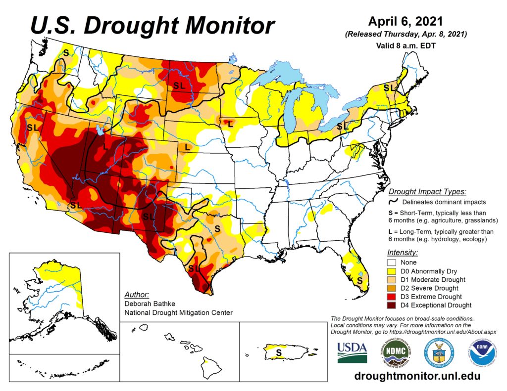
Drought Intensity
There are several categories of drought intensity.
- Abnormally Dry
- Moderate Drought
- Severe Drought
- Extreme Drought
- Exceptional Drought
Drought Impacts
The impact of drought are many, and include the geographical-environmental, agricultural, social, and economic.
Drought is obviously a high concern for farmers, those growing their own food, those dependent upon reservoirs being replenished to supply municipal systems, the animals and eco-systems, just to name a few…
I had my own personal impact last year when my region was technically in drought. I rely on a natural spring for my water source. Normally it wells up at about 7 – 10 gallons per minute. However it had slowed down to about 3 gallons per minute. It was still plenty for our homestead needs, but I did start to get a bit nervous about it…
The risk of drought is greater in some regions more than others. If you live in a drought-prone region, you probably already know it or have experienced it…
As of this post date, large regions of the southwest United States are in extreme drought or exceptional drought.
For your interest I have embedded several USA drought maps. They will auto-update to the latest images regardless of this article’s post date.
Realtime Drought Maps
Drought Monitor Map – droughtmonitor.unl.edu

United States Drought Map – noaa.gov
“Short-Term Drought Indicator”
USA Monthly Drought Outlook Map
“Drought Tendency” (Monthly)

United States Seasonal Drought Outlook Map
“Drought Tendency” (Seasonal)

United States Drought History
The use of tree ring methodology has revealed that the characterization of drought has been a normal part of climate throughout our history.
[ Read: United States Aquifer Locations ]